
Bemm River camping: the walk-in camp in East Gippsland, explained
Bemm River camping in East Gippsland: a flat, grassy walk-in camp for self-sufficient campers, how to find it, toilets, fishing and what to bring.
No live status · check conditions Forest Fire Management Victoria does not publish a live open or closed notice for this camp. Its page was last updated in July 2023. Check VicEmergency for fire danger and any total fire ban on the day. Checked on the operator's alerts page .
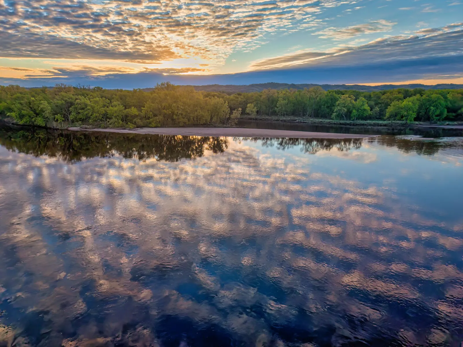
Bemm River camping in East Gippsland does not get much simpler than Camping Area 1: a grassy walk-in site on the bank of the Bemm River, a short drive from the settlement of the same name. It suits campers who are happy to carry gear a short way, bring their own toilet arrangements and spend the days fishing, birdwatching or exploring a quiet stretch of coast. The operator describes it as a camp for self-sufficient visitors, and that phrase shapes almost everything below. If you are weighing up free camping in Victoria, read the sections on rules and alternatives before you commit.
Where is Bemm River camping area 1?
The settlement of Bemm River sits on the north-western shore of Sydenham Inlet, roughly 4 km from the ocean beach. Wikipedia places it 59 km east of Orbost, 38 km south-west of Cann River and 431 km east of Melbourne, with a population of 72 at the 2021 census. Cape Conran Coastal Park borders the western side of the inlet and Croajingolong National Park the eastern side.
The Bemm River itself is 58 km long and runs through Bemm River Scenic Reserve and Cape Conran Coastal Park before reaching Bass Strait at the inlet. Much of its catchment is public land, including Errinundra and Lind national parks, and the habitats range from temperate rainforest to coastal heath and banksia woodland. The camp sits on licensed Crown water frontage, which matters because a neighbouring farmer may graze stock there.
The drive in and the final walk
From the post office in Bemm River, head west to Sydenham Inlet Road and follow it for 1.3 km. Turn right into Dollys Garden, then continue 300 m to a small parking area. The operator calls the parking limited. From there, follow the signs north for about 50 m on foot to the camp.
The operator lists the camp as walk-in only, with limited parking at Dollys Garden. Cattle graze the area, and mobile coverage may be available. Check current track conditions with Forest Fire Management Victoria before you leave. Leave gates as you find them: open stays open, closed stays closed. With limited parking and a final stretch on foot, this suits tents and swags, not caravans. The approach works for any vehicle that can carry you to the car park, but the parking itself is the constraint.
The camp itself
The camping area is moderately flat, open and grassy, on the river bank. The operator says no facilities are provided apart from public toilets nearby, and that a portable toilet is required, so pack accordingly. Camping is permitted only in the designated area, and visitors are asked to respect the neighbouring landholders and their privacy.
The one built facility is the set of public toilets in the adjacent council car park, about 50 m away. Otherwise bring a portable toilet or a poo pot. A portable toilet must be kept at least 50 m from the waterway, which on a bank camp means moving back from the river. Victoria’s general state forest guidance adds that wastewater from dishes should be poured at least 50 m from waterways, and that you should not wash in the water itself.
State forest campgrounds like this are generally free and do not take bookings. Confirm the current position with Forest Fire Management Victoria, since arrangements can change.
Walk-in campStyle
Public, 50 m awayToilets
AllowedFishing
AllowedTents
Who this camp suits, and who should choose somewhere else
It suits:
- Anglers who want to be on the water without driving far.
- Tent and swag campers comfortable with a toilet-and-water-carrying routine.
- Birdwatchers and walkers who like a quiet base.
Look elsewhere if you tow a caravan or long camper trailer, need showers or drinking water on site, or want marked sites with fireplaces. Third-party listings name Bemm River Caravan Park on Sydenham Inlet Road, and Banksia Bluff Camping Area in Cape Conran Coastal Park, which Wikipedia says has septic toilets, cold showers, tables and fireplaces. Listings also name Pearl Point Camp Area and Binn Beach Camp on Pearl Point Track and Gunnai Beach Camp Area on Pearl Point Road. Confirm each with its managing agency before relying on it.
What can you do near Bemm River?
Fishing is the headline. Bemm River is nicknamed the bream capital, and Visit East Gippsland lists bream and flathead, fished from a boat, the shore or the platforms around town. Fishing is allowed at the camp. Check Victorian fishing rules and licence needs first.
Other options within a short drive, according to the regional tourism site:
- McKenzie River Rainforest Walk, a 1 km loop in Bemm River Scenic Reserve with accessible paths, swinging bridges and interpretive signs.
- Binn Beach, just outside town, for swimming and quiet walks.
- Py-Yoot Bay, a few kilometres out of town, with sand and rock pools.
- Pearl Point, a remote beach with rock formations and high dunes. It has no facilities, so take what you need.
- The foreshore and Luderick Point Memorial Park in town, with jetties, picnic spots, barbecues and a playground.
A whale-watching platform is useful during the migration, which the tourism site places between April and November. Cape Conran Coastal Park, next door, adds short walks such as the Heathland Walk and East Cape Boardwalk, and its heathland and banksia woodland attract nectar-feeding birds. White-bellied sea eagles are among the birds recorded there, and dolphins and whales can be seen offshore depending on the season.
Further afield, Croajingolong National Park on the eastern side of the inlet has long beaches, headlands and almost 1,000 native plant species, and its eastern section is an Important Bird Area. Errinundra National Park, in the highlands behind the coast, protects what Wikipedia calls the largest remaining cool temperate rainforest in Victoria. Most of it is reachable only in drier months, because winter rain and snow usually close the unsealed roads.
Can you swim in the Bemm River?
No source says whether swimming is advised at the camp itself, and conditions on a river bank change with flow, depth and season. The tourism site recommends Binn Beach, just outside town, for swimming, and Cape Conran Coastal Park is described as suitable for swimming and rock pooling. Ask locally about the day’s conditions, and treat unpatrolled water with care.
Is there fuel at Bemm River?
Visit East Gippsland states that no fuel is available locally. Fill your vehicle, stove and any boat before you arrive. Orbost, 59 km west, and Cann River, 38 km north-east, are the nearest towns named in the sources.
Best time to visit and weather
The operator gives no seasonal closure but says to check track conditions before you go. No source gives weather records for Bemm River itself, so the nearest verified figures are for Orbost, 59 km west, from Bureau of Meteorology data for 2000 to 2022.
| Orbost, month | Mean max | Mean min | Average rainfall |
|---|---|---|---|
| January | 26.3 C | 14.9 C | 48 mm |
| July | 15.1 C | 5.6 C | 58 mm |
Annual rainfall at Orbost averages about 770 mm. The two months show the spread: warm days and mild nights in summer, cool days and nights near 5 C in winter. Summer suits swimming and beach days; autumn to spring suits whale watching. The sources give no figures for spring and autumn, so check the forecast close to your dates.
A one-night plan and a weekend plan
One night: arrive with daylight to spare, park at Dollys Garden, and carry your gear the 50 m to the camp. Set up away from the bank for toilet and wastewater distances, cook on a stove, and fish or watch birds along the river. Next morning, walk the 1 km McKenzie River Rainforest Walk or visit Binn Beach before driving out.
Weekend: add the foreshore and Luderick Point Memorial Park on day one, Pearl Point and Py-Yoot Bay on day two, and keep a spare morning for fishing. Buy supplies and fuel in Orbost or Cann River on the way in, since the town has a general store but no fuel.
Safety, fire and rules
Campfire rules in Victorian state forests are strict, and officers can issue on-the-spot fines. Check current fire restrictions and Total Fire Ban status before you go. On grassy ground with no built fireplace, a gas stove is the safer choice.
There are no bins in state forests, so carry out all rubbish and never bury or burn it. State forest camping is generally limited to 28 consecutive nights. Stock may graze the site, so keep food stored and gates as found. Dogs are not allowed, and campfires are not permitted.
What to bring: a planning checklist
- A portable toilet or poo pot, plus a plan for disposing of waste properly.
- All drinking water. The operator lists no water supply, so carry what you need.
- A stove and fuel, because open fires may be banned and the site has no fireplace.
- A tent you can carry 50 m, since you cannot drive to the camp.
- Fishing gear and any licence, if you plan to fish.
- Rubbish bags, and a full tank before you arrive.
- A printed note of the directions, because the route turns off a small local road.
Common mistakes
- Arriving with a caravan and finding only limited parking.
- Assuming there is fuel in town.
- Placing a portable toilet or washing dishes within 50 m of the river.
- Leaving a gate in a different state from how you found it.
- Lighting a fire without checking restrictions.
Wildlife and landscape notes
The river and inlet draw birdlife, and the tourism site notes that pelicans are common along the foreshore. Cape Conran’s heathland and banksia woodland support nectar-feeding birds, and Croajingolong is listed with 315 animal species, including eastern bristlebirds and pilotbirds in its eastern section. Errinundra National Park protects powerful owls, tiger quolls and long-footed potoroos, though those live in the highlands rather than at the camp.
The river’s name comes from a Gunai word meaning fish hawk. Croajingolong takes its name from Krauatungalung words meaning belonging to the east. Cape Conran Coastal Park was declared in 1997 and covers 11,700 hectares. For a camper, the practical meaning is that the camp sits in a mosaic of protected land, so expect good birdwatching and respect the rules of each reserve if you cross into one.
How to choose between this camp and its neighbours
Choose this camp when your priority is a quiet river bank, a short carry from the car and a base for fishing. Choose a caravan park or Banksia Bluff when you need amenities, showers or space for a trailer. Choose a beach camp such as Pearl Point or Binn Beach, as named in third-party listings, when you want the sea rather than the river, and confirm access and rules first. Whichever you pick, arrive with fuel, water and a plan for waste.
Supplies and services
Bemm River has a general store, a hotel that also runs as a licensed restaurant, and a caravan park. For a larger centre, Orbost and Cann River are the nearest towns named above.
More from the operator: forestsandreserves.vic.gov.au/land-management/managing-crown-land/camping-on-licensed-crown-water-frontages/bemm-river-bemm-river-camping-area-1.
Plan it in the app
Save the camp on your route in MotoRidez and the planner shows road closures along the way, and where your tank runs out once you have entered the range of your vehicle. Save the route for offline use before you lose signal: it saves the corridor around your route, not a whole region.
Details come from the operator’s own records and pages, read on 20 October 2026, and change. We do not show prices or availability. Confirm fees, bookings, closures and fire rules with the operator before you go.
Questions riders ask
Where is Bemm River camping area 1?
It is on the bank of the Bemm River near the Bemm River settlement in East Gippsland. From the post office go west to Sydenham Inlet Road for 1.3 km, turn right into Dollys Garden and continue 300 m to parking.
Are there toilets at Bemm River camping area 1?
Public toilets are about 50 m away in the adjacent council car park. Otherwise bring a portable toilet or poo pot, kept at least 50 m from the waterway.
Do you need a 4WD to camp at Bemm River?
The operator lists surface access as four-wheel drive. Check track conditions with Forest Fire Management Victoria before travelling.
Can you fish at the Bemm River camp?
Yes, the operator allows fishing, walking and birdwatching. The area is known for bream, and you should check Victorian fishing rules and licence needs.
Is there fuel at Bemm River?
Visit East Gippsland states no fuel is available locally. Fill up before arriving; Orbost is 59 km west and Cann River 38 km north-east.
Can you swim in the Bemm River?
No source confirms swimming at the camp. The regional tourism site recommends Binn Beach, just outside town, for swimming, so ask locally about conditions.
What is the weather like near Bemm River?
Nearby Orbost averages a January maximum of 26.3 C and a July minimum of 5.6 C, with about 770 mm of rain a year, per Bureau of Meteorology data for 2000 to 2022.
Free, no subscription
Plan the curvy bits. Record the ride.
Watch your
map fill in.
Curvy routing, turn-by-turn voice navigation, ride recording and your ridden-roads map, with nothing behind a paywall.



Join the waitlist
Bring MotoRidez to your roads
The more riders register from your region, the sooner we get there. Put your name down, then send it to your ride group to move your region up the queue.
You're on the list ✓
Nice — you're in the queue
Every rider you bring moves your region up the list. Share it with your mates and your ride groups.