
Meyers Flat camping area, Dargo: access, facilities and what to bring
Meyers Flat camping near Dargo: a forest camp on the Wonnangatta River with a toilet and fireplaces. Access, seasons, rules and what to bring.
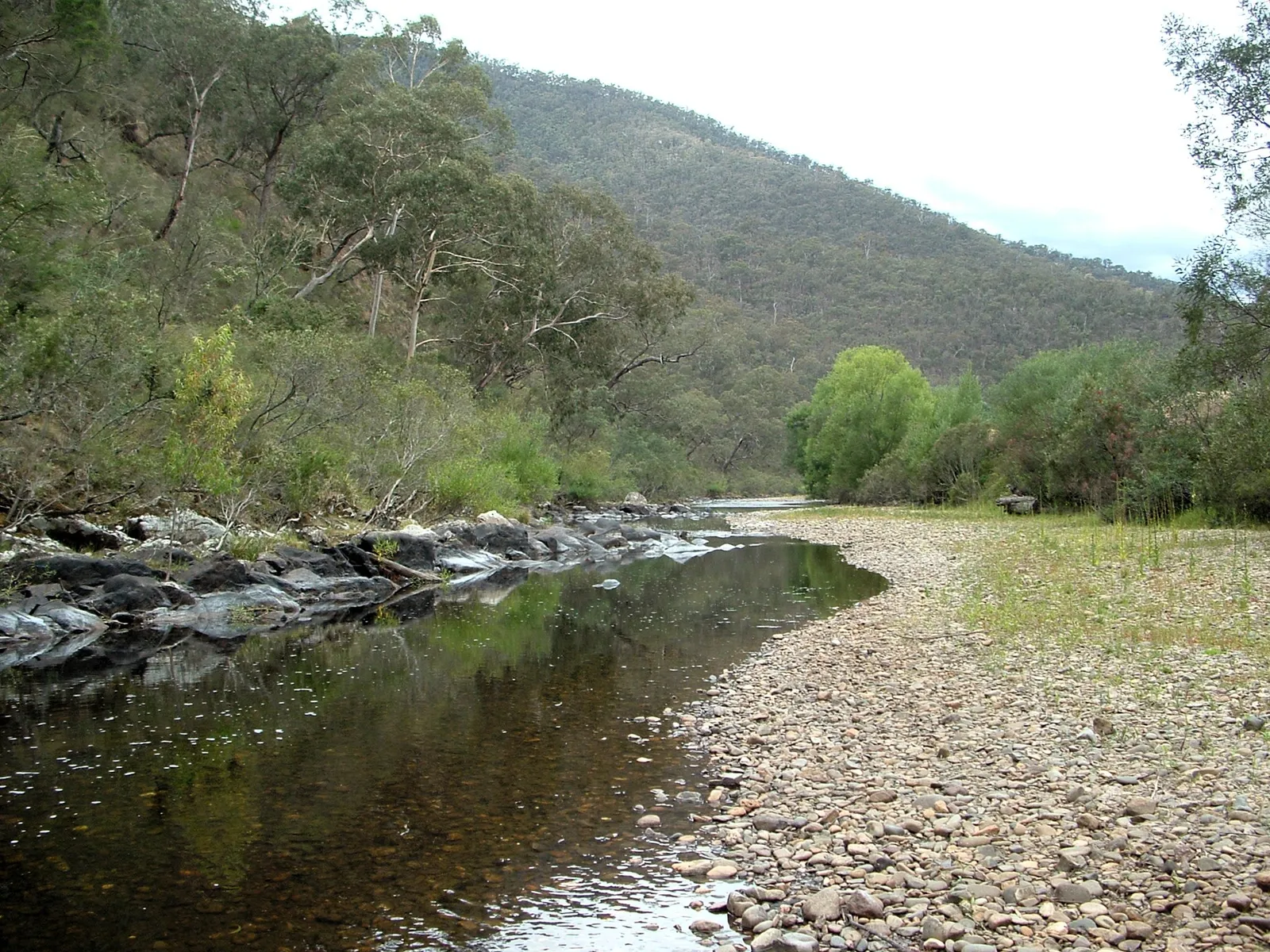
Looking for free camping in Victoria’s high country? Meyers Flat is a free forest camp on a bend of the Wonnangatta River, a short drive south of Dargo in East Gippsland. Forest Fire Management Victoria records it as a medium-sized site with a couple of camping areas, a toilet and fireplaces. It sits between the river and Dargo Road, so you can finish a day of driving and be camped beside running water within minutes. This guide covers the setting, the access, what the site offers, a one-night and a weekend plan, the seasons, safety, and the alternatives nearby, so you can decide whether it fits your trip.
Where is Meyers Flat, and what is the setting?
The operator places Meyers Flat about 15 km south of Dargo, roughly 3 km downstream from the Waterford Bridge. The Wonnangatta is a perennial river that rises below Mount Despair on the Great Dividing Range and winds about 151 km, dropping more than a kilometre in height, before helping to form the Mitchell River. Its name comes from the Gunai language, though the meaning is not clearly defined.
Dargo sits between the foothills of the Victorian Alps and the Alpine National Park, and Visit Gippsland calls it one of the most remote communities in Victoria. The valley floor is known for century-old walnut avenues. Wikipedia counts about 105 residents at the 2021 census, which gives a sense of how quiet the district is. Expect forested hills, a river and very little traffic after dark.
The drive in and the access
Meyers Flat is beside Dargo Road, so there is no side track to negotiate. The operator lists the site as suited to camper trailers, and tents and caravans are recorded as allowed. One published figure puts Dargo roughly 348 km east of Melbourne (Wikipedia’s infobox gives 314 km), and a 4WD magazine describes about four hours of driving. The route into town crosses the Wonnangatta River. The road suits any vehicle, but allow time on country roads and expect to arrive with limited phone and shop options.
The caveat is closures. The operator notes that the Dargo roads are seasonal and subject to closure. A published example is the Dargo High Plains Road above town, which local councils close for the snow season. Before leaving, check VicTraffic and ring the Dargo Hotel or Dargo General Store for local conditions rather than trusting an old map.
What is the camp like?
The operator’s record is modest and worth taking literally. It lists a toilet and fireplaces, welcomes tents and caravans, and notes no wheelchair access. Drinking water, showers and rubbish collection are not recorded, so assume none. A travel blog describes a shaded, grassed area with fire pits and picnic tables, popular for swimming and fishing. Treat that as colour rather than a guarantee.
With a couple of separate camping areas, groups can spread out rather than share one paddock. State forest campgrounds like this are generally free and do not take bookings, but confirm with the operator if you need certainty.
Do not confuse it with a different listing on the Forests and Reserves website, Wonnangatta River Dargo Camping Area 1 and 2, about 13 km south of Dargo. That is a walk-in riverbank area with no facilities, a portable toilet required, no campfires, no dogs, and grazing cattle. Do not assume those rules apply at Meyers Flat, or the reverse; read the signage on arrival.
Who does Meyers Flat suit, and who should go elsewhere?
It suits self-sufficient campers who want a free, no-booking riverside base: a swag, a hiking tent, a camper trailer or a caravan. It also works as the first night of a longer trip into the Wonnangatta country, with Dargo’s fuel and food close by.
Choose somewhere else if you need drinking water, showers or power, or step-free access. The Wonnangatta Caravan Park at 7611 Dargo Road is listed by a directory as having a wider range of facilities, although that listing is unclear about which apply, so phone the park first. If you want a pub meal within walking distance, a travel page says free camping is currently allowed behind the Dargo Hotel, with shade by the river; call the hotel for current information. If you have a high-clearance four-wheel drive and want something more remote, Talbotville, Black Snake Creek and Horseyard Hut are riverside options described by 4WD sources.
A one-night plan and a weekend plan
One night. Buy fuel, food and ice in Dargo before you arrive, since the operator records no services at the camp. Pitch early enough to choose a flat spot and gather your wood or check your stove. Spend the late afternoon at the river, cook, and expect cold air to settle along the water after dark. In the morning, pack out all rubbish and put out any fire with water.
Weekend. Use the first evening as above. On the second day, drive into Dargo for a look at the general store and a meal at the hotel, which was established in 1898 and is known for hosting live country acts. The Dargo Heritage Museum opens by request, so ring ahead if you want to see it. Spend the afternoon fishing or walking the riverbank, then return for a second night. If you have a suitable four-wheel drive, a half-day run toward the old mining sites around Grant and Talbotville is possible, but treat it as a separate, more demanding trip.
What can you do near Meyers Flat?
Fishing and swimming. Trout and redfin fishing are listed among the district’s draws, and one paddler calls the trout fishing excellent. River levels vary, and the same author warns that summer flows can fall too low to rely on, so look at the water before planning around it.
History. Dargo was a stopover for miners heading to the gold rush fields of Grant, Talbotville and Crooked River, and its post office opened in 1868. The general store was built on foundations brought from Talbotville. Grant Historic Mining Area lies near the Wonnangatta valley.
Den of Nargun. This site sits on the Bataluk Cultural Trail and holds a Gunaikurnai legend. Visitors are asked not to enter the cave.
Walking. Dargo is a gateway to Mitchell River National Park, with gorges and rainforest gullies; the Mitchell River Walking Track is listed as 18 km over two days. In the Alpine National Park, the Bryce Gorge Circuit offers views of Bryces Gorge and Pieman Falls.
Four-wheel-drive and horse touring. Routes run to Wonnangatta Station and Billy Goat Bluff, one of the steepest tracks in Victoria. Coonawarra Trail Rides offers horseback trips. These suit equipped vehicles and experienced people, not caravans.
Nature. The same paddler describes sandy beaches, bank overhangs where small birds nest, fire-killed timber and loud bird choruses at dawn and dusk. A bird call is the likeliest alarm clock.
When is the best time to visit?
The only climate record found for the district is Wikipedia’s table for the Mount Moornapa station at 480 m, a different location from the camp, so treat it as a guide only.
| Season | What the sourced figures show |
|---|---|
| Summer (January) | Mean maximum 25.5 degrees Celsius, minimum 13.4. Record high 43.7. |
| Winter (July) | Mean maximum 12.3, minimum 5.3. Record low minus 7.9 (August). |
| Year-round | Annual rainfall about 874 mm. Mean daily maximum 18.7, minimum 9.2. |
| Spring and autumn | No figures found. Check forecasts, and check road status. |
Late spring to autumn is the practical window for most people, because winter nights are cold and the Dargo roads are seasonal. In any month, check road status first.
Can you light a campfire at Meyers Flat?
The operator records fireplaces, so fires are expected, but conditions decide. Published Victorian guidance says a campfire must be in a proper fireplace, smaller than one square metre, and kept three metres clear of flammable material. Someone must stay with it until it is out, and water is the way to put it out. Campfires and portable gas or liquid fuel stoves are banned on Total Fire Ban days, so check VicEmergency or the hotline on 1800 226 226. I could not find an official Meyers Flat page, so confirm site-specific rules with Forest Fire Management Victoria.
Safety, wildlife and rubbish
Cattle graze parts of the riverbank country nearby, so keep food and rubbish secured. Dargo is also visited by hunters of sambar deer, so wear visible clothing if you walk off the camp. Treat river water before drinking it. The nearest help is the Dargo Bush Nursing Centre, which handles minor ailments only and refers serious cases to Sale or Bairnsdale hospitals; its listed hours are Tuesday to Saturday, so do not count on it on a Sunday or Monday. Carry out all your rubbish.
Planning checklist
Before you leave
- Check road status, VicEmergency warnings and the fire danger rating.
- Fill the tank and buy food in Dargo or earlier.
- Download an offline map.
On arrival
- Read any signage and confirm which area you are in.
- Choose a flat spot away from dead branches.
- Locate the toilet and the fireplaces.
Before you pack up
- Put out the fire with water and check it is cold.
- Collect all rubbish, including small items.
- Leave the camp tidier than you found it.
Common mistakes and how to avoid them
- Assuming water is provided. It is not recorded, so carry every litre.
- Relying on a fire for cooking. Carry a stove for ban days.
- Arriving late in winter. Daylight is short and nights are cold.
- Skipping the closure check. The Dargo roads are seasonal.
- Mixing up the two Dargo listings and their different rules.
What to bring
- Drinking water and a way to treat river water.
- A backup stove and warm layers.
- Toilet paper, rubbish bags and a trowel.
- A paper or offline map.
Supplies and services
Dargo General Store sells fuel, takeaway food, a small range of groceries and maps, and the Dargo Hotel serves meals. One author names Guy’s Caravan Park, near the Waterford Bridge turn-off, as the last fuel and ice stop before the Wonnangatta Road; ring ahead to confirm. Bairnsdale, about 74 km away by a directory’s reckoning, is the larger town for a full shop.
More from the operator: exploreoutdoors.vic.gov.au/activities/camping.
Plan it in the app
Save the camp on your route in MotoRidez and the planner shows road closures along the way, and where your tank runs out once you have entered the range of your vehicle. Save the route for offline use before you lose signal: it saves the corridor around your route, not a whole region.
Details come from the operator’s own records and pages, read on 20 October 2026, and change. We do not show prices or availability. Confirm fees, bookings, closures and fire rules with the operator before you go.
Questions riders ask
Where can you camp for free in Victoria?
Victoria has many free state forest and bush camps. Meyers Flat, beside Dargo Road about 15 km south of Dargo, is one the operator records with a toilet and fireplaces. Confirm with Forest Fire Management Victoria before you go.
Is Meyers Flat free to camp?
State forest campgrounds like this are generally free and do not take bookings, but confirm with Forest Fire Management Victoria.
What facilities does Meyers Flat have?
The operator records a toilet and fireplaces, and no wheelchair access. Drinking water, showers and rubbish collection are not recorded, so bring water and take your rubbish home.
Can I take a caravan or camper trailer to Meyers Flat?
Yes, the operator lists tents and caravans as allowed and the site as suited to camper trailers. Check road conditions first, as the Dargo roads are seasonal.
Where is the nearest fuel and food to Meyers Flat?
Dargo is the nearest town. Its general store sells fuel and a small range of groceries, and the Dargo Hotel serves meals.
Can you light a campfire at Meyers Flat?
The operator records fireplaces, but fires are banned on Total Fire Ban days and must be small and kept clear of flammable material. Check VicEmergency and confirm site rules with the operator.
When is the best time to camp near Dargo?
Late spring to autumn is the practical window. A nearby weather station records mean July maximums of 12.3 degrees Celsius and minimums of 5.3, and the Dargo roads are seasonal.
Free, no subscription
Plan the curvy bits. Record the ride.
Watch your
map fill in.
Curvy routing, turn-by-turn voice navigation, ride recording and your ridden-roads map, with nothing behind a paywall.
Join the waitlist
Bring MotoRidez to your roads
The more riders register from your region, the sooner we get there. Put your name down, then send it to your ride group to move your region up the queue.
You're on the list ✓
Nice — you're in the queue
Every rider you bring moves your region up the list. Share it with your mates and your ride groups.