
Howittville camping on the Crooked River: access, rules and what to expect
Howittville camping area 1 on the Crooked River near Dargo: four-wheel-drive access, river crossings, rules, roadworks and what to check first.
Seasonal camp · check closures Forest Fire Management Victoria says this is a seasonal camping area: drive to the conditions and follow any road closures. Parks Victoria lists fire recovery roadworks on McMillans Road from 24 September to 30 November 2026. Checked on the operator's alerts page .
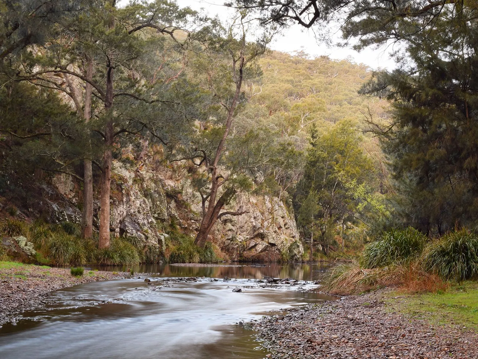
The Howittville camping area on the Crooked River is a remote riverside camp in the Dargo high country of Gippsland, Victoria, reachable only by four-wheel drive through at least one river crossing. This guide covers Crooked River Howittville camping area 1: how the access works, what the operator says about the site, when to go, what to pack and where to camp instead if the river is up or the site is closed. It is written for anyone choosing a camp, whatever they are driving or riding, and everything here comes from the operator’s record or the published sources listed with the guide.
Which Howittville is this? Area 1 versus the other areas
The operator groups its Crooked River riverbank sites as Howittville areas numbered 1 to 4, and this guide is about Area 1. Separately, Parks Victoria manages a Crooked River Camping Area in the Grant Historic Area, and Talbotville Historic Township Camping Area nearby. They are different camps with different managers and rules. The operator’s record for Area 1 places it near the Talbotville historic area, with the camping areas 200 m beyond the river crossing on one route. If you search maps or camping apps, check that the name, number and land manager match before you drive in.
What is the Howittville camping area like?
The camp sits on the banks of the Crooked River, a perennial river in the Mitchell River catchment that runs about 26 km before joining the Wongungarra River inside the Alpine National Park. The river falls roughly 366 m from source to mouth, so it is a lively stream rather than a still pool.
The operator describes a self-sufficient camp with no recorded facilities. The site is licensed Crown water frontage, so camping is allowed in the designated area only, and a neighbouring farmer may graze stock there. Visitors are asked to respect the landholders’ farming and privacy, and to take all rubbish home. There are no listed toilets, tables, taps or bins: it is a bush camp where you choose a spot within the designated area and carry out your own waste.
How hard is the drive in, and do you need a 4WD?
Yes. Access is strictly four-wheel drive and needs at least one river crossing in your vehicle on both routes. Both start at Dargo, and both use seasonal roads that can close.
Route 1 leaves the Dargo Hotel along Lind Avenue for 1 km, then Dargo Road for 4.8 km, Shortcut Road for 2.3 km and Wonnangatta Road for 21.2 km. Talbotville Road follows for 6.1 km, then Crooked River Track and Randalls Track lead to a parking area before the crossing. That is about 35 km of road before the tracks, and the route crosses the river before the Talbotville camping area.
Route 2 heads north on Lind Avenue, then follows Dargo High Plains Road for 15.3 km and McMillans Road for 15.7 km, about 31 km in total. Crooked River Track then goes through a river crossing, with the camping areas 200 m on.
A published four-wheel-drive account describes the narrow track in from the south as having several creek crossings that are manageable normally but become difficult if the river runs deeper than usual after heavy rain. Treat river height as your deciding factor. Parks Victoria also lists fire recovery roadworks on McMillans Road between Talbotville and the Grant Historic Area from 24 September to 30 November 2026, with possible delays, stop-go traffic and short closures.
4WD onlyAccess
On both routesRiver crossings
None, bring a portable toiletFacilities
Self-sufficientCamping style
Is Howittville open? Fire closures and seasonal roads
Check first. When the operator’s data was last refreshed on 20 September 2026 the site was listed as closed because of fire conditions, with a reopening date that has since passed. The roads are seasonal, so a gate can be shut even when the camp is not. Confirm the current status with Forest Fire Management Victoria before you plan around the trip.
When is the best time to camp near Dargo?
The climate table available is for Dargo, at about 480 m elevation, using the nearest weather station at Mount Moornapa (1993 to 2025). The camp is in a river valley, so treat these as a guide.
| Season | Months | Mean maximum | Mean minimum | Rain days per month |
|---|---|---|---|---|
| Summer | Dec to Feb | 23.3 to 25.5 C | 11.4 to 13.4 C | 10 to 11 |
| Autumn | Mar to May | 15.0 to 22.2 C | 7.9 to 12.1 C | 10 to 13 |
| Winter | Jun to Aug | 12.3 to 13.8 C | 5.3 to 6.0 C | 14 |
| Spring | Sep to Nov | 16.5 to 21.2 C | 7.0 to 10.0 C | 13 to 14 |
Annual rainfall averages 874 mm, with November the wettest month at 113 mm and May the driest at 47 mm. The record high is 43.7 C and the record low is minus 7.9 C. Wet months mean higher rivers, so a dry stretch is more useful than a particular calendar month.
One night or a weekend: sample plans
For one night, fuel up and buy supplies in Dargo, check the river and closures that morning, and allow daylight both ways, since the first route alone is about 35 km before you reach the tracks. Set up, then spend the afternoon by the river.
For a weekend, use the extra day for Talbotville and the Grant Historic Area rather than extra driving. Move the vehicle only when you need to, keep water and fuel in reserve, and plan to leave with margin if rain is forecast, because a crossing that was easy on arrival can change overnight.
What can you do near Howittville?
Fishing and walking are the draws the operator names, and Dargo is known for trout fishing, so bring a rod and check current Victorian fishing rules.
Gold was found along the Crooked River in 1861. The settlement at Talbotville was first called Ram Town, became the main centre when mining shifted to reef gold, and outlasted the other river towns: the last family left in 1950. A visitor listing notes that a few stone walls and old workings remain. Grant, in the hills nearby, was once the largest of the settlements around the river, and Parks Victoria manages the Grant Historic Area. Dargo itself began as a stopover for miners heading to these goldfields, and its post office opened in 1868.
Beyond the camp, a few outings make sense from this base. The Talbotville flats are close, and a visitor listing for the area notes lush grass along the river even when the surrounding bush is dry, plus old mine sites upstream such as the New Good Hope Mine. The same listing reports that the track in from Grant is steep and rough in parts, which is worth knowing before you plan a loop that uses it. One 4WD account names Billy Goat Bluff, the Wonnangatta Valley and Blue Rag, reached by Brewery Creek Road, as destinations people base themselves at Talbotville to reach, so a second day can go further afield for those with the vehicle and time. Bulltown, further upstream, was the main town of the goldfield, but the same account describes the track as challenging, so treat it as an experienced-driver outing.
Who should camp here, and who should choose elsewhere?
Choose Howittville if you have a capable four-wheel drive or off-road camper, want a quiet river camp and are happy to be self-sufficient. Choose somewhere else if you need toilets, tap water, easy road access or certainty, or if the river is running high.
Verified alternatives nearby include Talbotville Historic Township Camping Area, which Parks Victoria describes as four-wheel-drive access on the grassy flats of the Crooked River and where dogs are allowed off leash. Parks Victoria’s Crooked River Camping Area in the Grant Historic Area does not allow dogs. A published account also mentions camping behind the Dargo pub. Check each place’s current status first.
Can you reach it in any vehicle?
The operator’s wording is strict: four-wheel drive, with a river crossing in your vehicle. That rules out ordinary cars, caravans and most bicycles carrying full loads. A camper trailer is a judgement call that depends on your tow vehicle, the depth of the crossing that day and the track behind it; the operator does not give a depth or clearance figure, so there is no number to rely on. If you are unsure, camp at Dargo first and ask locally about the river.
What are the rules, risks and wildlife concerns?
Fire is the main hazard in this country, so check fire danger and any total fire ban on the day. The operator (Forest Fire Management Victoria) lists campfires as not permitted and dogs as not allowed. It lists no facilities and says a portable toilet is required. It also warns that sheep and cattle may graze the area, and that the camp is seasonal: drive to the conditions and follow any road closures. The page was last updated in July 2023, so check it again before you go. Take all rubbish home, camp only in the designated area, and expect stock on the frontage, so secure food and gear.
Parks Victoria warns of falling trees at the nearby camps, so avoid camping under dead limbs, and flags European wasps at Talbotville. It also asks visitors not to touch or approach sick or dead birds or other wildlife during H5 bird flu management.
What should you bring?
Bring drinking water for the whole stay, since no tap is listed, and treat river water. Pack a portable toilet system, rubbish bags, a gas stove and recovery gear such as a snatch strap and a tyre repair kit with compressor. Footwear you can wet helps when checking the crossing on foot. Carry offline maps, a first-aid kit and a satellite messenger, plus warm layers for cold nights and a rod if you plan to fish.
Planning checklist
- Before you leave: confirm the site and road status, check river level and weather, tell someone your route, fill the tank and water containers in Dargo.
- On arrival: find the designated area, keep clear of dead branches, set up away from stock paths and secure food.
- Before packing up: collect all rubbish, check the area for loose items, and recheck the crossing before you leave.
Common mistakes to avoid
- Assuming the camp is open because roads were open last time.
- Crossing after heavy rain without checking the depth.
- Confusing Howittville Area 1 with the Parks Victoria camps in the Grant Historic Area.
- Counting on a toilet or tap that is not listed.
- Camping outside the designated area on private grazing land.
Where to get supplies
Dargo is the last practical stop. It has the Dargo Hotel, a store described as an important refuel and resupply point, and a community hall. The town had 105 residents at the 2021 census, so do not expect a full range of goods.
More from the operator: forestsandreserves.vic.gov.au/land-management/managing-crown-land/camping-on-licensed-crown-water-frontages/Crooked-River-Howittville-1,-2,-3-and-4.
Plan it in the app
Save the camp on your route in MotoRidez and the planner shows road closures along the way, and where your tank runs out once you have entered the range of your vehicle. Save the route for offline use before you lose signal: it saves the corridor around your route, not a whole region.
Details come from the operator’s own records and pages, read on 20 October 2026, and change. We do not show prices or availability. Confirm fees, bookings, closures and fire rules with the operator before you go.
Questions riders ask
Is Howittville camping area free?
State forest campgrounds like this are generally free and do not take bookings, according to the operator's record. Check with Forest Fire Management Victoria for current status.
Do you need a 4WD to camp at Howittville on the Crooked River?
Yes. The operator describes access as strictly four-wheel drive, with at least one river crossing in your vehicle on both routes from Dargo.
What facilities does Howittville camping area have?
None are recorded. It is self-sufficient camping, so bring water and a way to manage toilet waste, and take all rubbish home.
How do you get to Howittville from Dargo?
Route 1 uses Shortcut Road, Wonnangatta Road, Talbotville Road and Crooked River Track; route 2 uses Dargo High Plains Road and McMillans Road to Crooked River Track and a river crossing, with the camping areas 200 m on. Roads are seasonal.
Is Howittville camping area open right now?
The operator does not publish a live open or closed status for this camp. It is a seasonal camp, so drive to the conditions, follow any road closures and check VicEmergency for fire danger on the day.
What is the difference between Howittville and Talbotville camping?
Howittville is an operator-listed Crown water frontage camp with no facilities recorded. Talbotville is a separate Parks Victoria camping area on the Crooked River flats, where Parks Victoria says dogs are allowed off leash.
When is the best time to camp near Dargo?
Dargo's long-term mean maximum runs from 12.3 C in July to 25.5 C in January. River height and fire conditions matter more than the month, so check both before you go.
Free, no subscription
Plan the curvy bits. Record the ride.
Watch your
map fill in.
Curvy routing, turn-by-turn voice navigation, ride recording and your ridden-roads map, with nothing behind a paywall.



Join the waitlist
Bring MotoRidez to your roads
The more riders register from your region, the sooner we get there. Put your name down, then send it to your ride group to move your region up the queue.
You're on the list ✓
Nice — you're in the queue
Every rider you bring moves your region up the list. Share it with your mates and your ride groups.