
Newnes camping, Wollemi: walk-in access, booking and what to expect
Newnes camping in Wollemi National Park: walk-in access, booking, fire rules, pets, Glow Worm Tunnel and what to bring.
Open · park closes 9 to 12 Nov 2026 NPWS lists no alert for the campground itself, but Wollemi National Park has a closure from the evening of 9 November to the morning of 12 November 2026 for feral animal control, a fire ban to 31 March 2027 on nearby Newnes tracks, and roadworks to 31 December 2026. Checked on the operator's alerts page .
Map: Newnes and what is around it
Pan and zoom. Solid lines are sealed roads, dashed brown lines are gravel and unsealed roads, and purple lines are named twisty roads. Tap a pin or a road for details, and use the buttons to switch layers on and off.
The interactive map needs WebGL, which this browser does not offer. The places around the camp are listed below.
Lookouts, waterfalls and peaks
- Mystery Mountain Lookout Lookout · 0.9 km
- Pagoda Lookout Lookout · 2.5 km
- Lookout towards Pantoneys Crown Lookout · 14.0 km
- Wolgan Gap Lookout · 16.6 km
- Carne View Lookout Lookout · 16.7 km
- Genowlan Point Lookout · 18.4 km
- Wolgan Falls Waterfall · 17.9 km
- Mystery Mountain Peak · 1.1 km
- Red Rocks Peak · 3.7 km
- Mount Canobla Peak · 5.1 km
- Mount Dawson Peak, 990 m · 5.2 km
Fuel
- BP Capertree 23.7 km in a straight line
- Fuel station 28.9 km in a straight line
- Wallerawang Service Station 30.9 km in a straight line
- BP 31.3 km in a straight line
Food and coffee
- From the Paddock 9.7 km
- Wolgan Dining Room 9.8 km
Other camps nearby
- Glen Davis Reserve Campground 6.5 km
- Twilight Canyon Creek campsite 7.5 km
- Coorongooba Camping Area 9.7 km
- Mining Hut 19.0 km
Distances are in a straight line from the camp, not by road. Places and roads come from OpenStreetMap and can be out of date: confirm fuel and opening hours before you rely on them. An unsealed road on the map is not necessarily open to vehicles, and in national parks many are fire trails, so check the park alerts and signs. Map data © OpenStreetMap contributors.
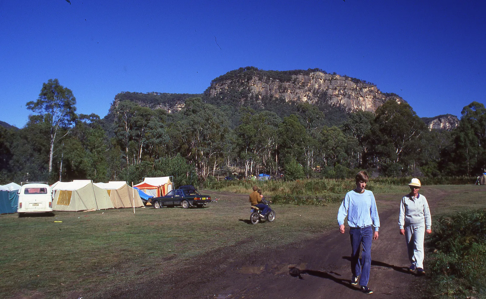
Newnes camping in Wollemi National Park puts you on a grassy, flat stretch beside the Wolgan River, under sandstone cliffs, at the site of an abandoned shale oil works north of Lithgow and the Blue Mountains. It is the base for the Glow Worm Tunnel and the industrial ruins around Newnes, and it is run by the NSW National Parks and Wildlife Service (NPWS). The most important thing to know before you plan anything is that, at the time of writing, the NPWS lists it as walk-in only. That changes who it suits, so read the access sections before you pack the car.
What is Newnes and why camp here?
Newnes is a former oil shale mining site in the Wolgan Valley, in the Central Tablelands. Wikipedia places it 49 kilometres north of Lithgow and 186 kilometres west-northwest of Sydney, at an elevation of 516 metres, partly surrounded by Wollemi National Park. Construction of the works began in 1906 and the retorts were first charged in 1911. The village was first called Wolgan and was renamed in early 1907 after Sir George Newnes, chairman of the Commonwealth Oil Corporation.
The population peaked at about 800 in 1907, dropped to 96 by 1914 and had shrunk to four families by 1940. Mining moved north to Glen Davis in the Capertee Valley. A 50-kilometre railway once linked it to the Main Western line; the rails are gone but the Glowworm Tunnel remains, and the NPWS describes shale oil ruins with tracks, tunnels and ovens around the campground.
The NPWS describes it as suited to self-sufficient, adventurous campers.
Can you drive to Newnes campground?
Not currently. The NPWS page says there is no vehicle access and the campground can only be reached on foot. The reason it gives is that Wolgan Road, the only vehicle route into the valley, has collapsed, and there is a landslip risk at Wolgan Gap. A 2024 cycling article dates the washout to November 2022. The NPWS did not publish a reopening date on the pages checked, and the road is a council matter, so treat any older report of people driving in as out of date.
The listed route is the Pipeline track from Glen Davis, roughly 10 kilometres each way. A late-2025 NPWS alert for the Glow Worm Tunnel area also named Old Coach Road from Newnes Plateau as a way in to the Newnes ruins and campgrounds, but that alert has since expired, so confirm it before relying on it.
This is why the camp suits hikers, bikepackers and well-prepared backpackers far better than car campers, caravans or camper trailers. If you carry everything for 10 kilometres, pack for it: water treatment, food, your own firewood if you want a fire, and a way to carry rubbish out.
How do you get to the Glow Worm Tunnel and the Glen Davis end?
The two ends of the valley are very different drives.
For the tunnel, Wikipedia describes a drive from Lithgow via State Mine Gully Road, or from Clarence via the Old Bells Line of Road, onto Glowworm Tunnel Road. That is about 25 kilometres of unsealed road, passing through another former rail tunnel to a car park, then a 1 kilometre walk to the tunnel. A large gap in the road on the south side of the tunnel stops vehicles from going further. Check the current road conditions with the NPWS before you drive any of it.
NPWS lists Wollemi National Park as closing from the evening of 9 November to the morning of 12 November 2026 for feral animal control operations, and a fire ban from 8 October 2026 to 31 March 2027 on Newnes-area sites such as the Newnes Industrial Ruins walk. The alerts page for the campground showed no alert when it was read on 29 October 2026, so check the park alerts before you go.
Roadworks matter right now. The NPWS alerts show construction at the Bungleboori precinct until December 2026, with the Bungleboori site closed to visitors and Glowworm Tunnel Road narrowed to a single lane from 11 October, with delays of up to five minutes. State Mine Gully Road has closures for roadworks listed for late October, and Lost City Road is closed. Haulage trucks use the Old Bells Line of Road on weekdays and Saturday mornings, with a 40 kilometre per hour limit, and drivers are told to monitor UHF channel 11.
Walk-in onlyVehicle access
Via NPWSBooking
None; booking feeCamping fee
NoneDrinking water
What is the campground like?
The sites are unpowered and unmarked, so you choose a flat spot on the grass. Toilets are non-flush. There is no drinking water: bring your own, and the NPWS says to treat or boil creek water if you use it. There are wood barbecues and fire rings, but you bring your own firewood, and collecting firewood in the park is not allowed. You can also camp on the far side of the river. The NPWS says that side is reached only on foot or by 4WD across the ford, and warns that the river level can rise rapidly, so check conditions before crossing.
Facilities are basic by design. Limited mobile coverage means you should not count on calling for help; the NPWS recommends downloading the Emergency Plus app before you leave for use with Triple Zero (000).
Do you need to book Newnes campground?
The NPWS publishes Newnes as a bookable campground. You can book online for groups of up to 20 people or five sites, and larger groups submit a group booking enquiry. You can also book through the National Parks Contact Centre on 1300 072 757, which the page lists as open 7am to 7pm daily, or by email. The Oberon office runs the campground.
How much does Newnes camping cost?
The NPWS says there is no camping fee, but a booking fee applies. Confirm on the official page when you book.
Can you light a campfire at Newnes?
The NPWS has a park fire ban for Wollemi National Park from 1 October 2026 to 31 March 2027, which prohibits campfires and solid-fuel barbecues and stoves across the park. The alert states that Newnes campground is exempt from that ban. Gas and electric barbecues are allowed with conditions elsewhere. The campground page also shows a fire ban alert, so read the local alerts page before you go and obey any total fire ban declared on the day. The park may also close because of poor weather or fire danger. If you use a fire ring, bring all your own wood, because collecting wood is not permitted.
Is Newnes campground dog friendly?
No. Pets are not permitted, except certified assistance animals. Recreational drone flying is prohibited, smoking is not allowed, and commercial filming or photography needs prior consent. All rubbish must be taken out.
When is the best time to camp at Newnes?
The NPWS suggests autumn for photography, spring for canoeing at Ganguddy (Dunns Swamp) and summer for guided Glow Worm Tunnel tours. There is no climate station at Newnes in the sources used here. The table below uses Lithgow, which sits at 950 metres, much higher than the 516 metres at Newnes, so expect the valley to be somewhat milder, with cold winter nights still likely. Wikipedia describes Lithgow’s climate as oceanic, with snow rare and usually light.
| Season | Lithgow mean max | Lithgow mean min | What it means for a walk-in camp |
|---|---|---|---|
| Summer (Dec to Feb) | 24.5 to 25.5 | 10.4 to 12.1 | Warm days, with fire danger and tour season |
| Autumn (Mar to May) | 14.3 to 22.4 | 3.9 to 10.1 | Cooler, favoured for photography |
| Winter (Jun to Aug) | 10.4 to 12.0 | 0.7 to 1.8 | Cold nights, bring a warm sleeping bag |
| Spring (Sep to Nov) | 15.4 to 21.5 | 3.4 to 8.1 | Mild, good for canoeing at Ganguddy |
Lithgow’s record low is minus 8.0 degrees Celsius in July and August and its record high is 38.4 in February. It averages about 860 millimetres of rain a year. Heavy rain has caused landslips on the valley tracks and can raise the Wolgan River.
What is there to do near Newnes?
- Explore the shale oil ruins, with tracks, tunnels and ovens, and swim in the river, as the NPWS describes.
- Visit the Glow Worm Tunnel. The tunnel is 402 metres long and is home to the larvae of the glow-worm Arachnocampa richardsae. Wikipedia lists walks of about 1 kilometre from the Glowworm Tunnel Road car park, about 9 kilometres return from the Wolgan River weir, and about 11 kilometres each way along the old railway from Newnes. Take a torch.
- Paddle at Ganguddy (Dunns Swamp), which the NPWS lists as one of the nearest campgrounds and recommends for canoeing in spring.
- Walk the old railway toward the tunnel. A late-2025 NPWS alert closed the section from the tunnel exit to the Four Ways intersection after landslips, so check the current track alert.
What should you bring to Newnes?
- All drinking and cooking water, plus a way to treat creek water
- Food and a stove, and your own firewood if you plan to use a fire ring
- A tent, warm sleeping gear and wet-weather cover
- A torch or headlamp for the tunnel and for camp
- Rubbish bags, because all rubbish must be carried out
- The Emergency Plus app, downloaded in advance
- Offline maps, since coverage is limited
Where are the nearest supplies?
Lithgow is the main town. Wikipedia gives its 2021 census population as 12,385, and says it has a major shopping centre, Lithgow Valley Plaza, on the Great Western Highway about 150 kilometres west of Sydney. Buy fuel, food and gear there. Glen Davis has no services confirmed in the sources used here, so treat the campground as fully remote.
A one-night plan and a weekend plan
For one night, book ahead, reach Glen Davis in the morning, walk the Pipeline track in daylight, set up camp and spend the evening at the ruins. Walk out the next morning.
For a weekend, give yourself a full day between walks in and out. Spend it at the ruins, in the river, or on the old railway toward the Glow Worm Tunnel. Check track alerts for the Four Ways section before you commit to the tunnel walk from Newnes, and keep time in hand for the return.
Who is Newnes for, and where else could you camp?
Newnes suits fit walkers, bikepackers and campers who want a quiet, self-sufficient night among ruins. It does not suit people towing a caravan or camper trailer, anyone with a dog, or anyone who needs tap water and flush toilets.
If that rules you out, consider these options:
- Coorongooba campground, also in Wollemi National Park on the Capertee River near Glen Davis. The NPWS lists unpowered sites, toilets, barbecue facilities, picnic tables and two accessible campsites, with no camping fee but a booking fee.
- Ganguddy (Dunns Swamp), which the NPWS lists among the nearest campgrounds and recommends for paddling.
- Bush camping in Gardens of Stone State Conservation Area, which the NPWS alerts say is allowed more than 200 metres from park infrastructure. Several roads and the area west of Glowworm Tunnel Road are closed for a new visitor precinct, so check the alert.
Planning checklist
- Read the NPWS campground page and local alerts the day before you leave
- Confirm the access route and any closures at the Kanangra Area office on (02) 6336 6200
- Book through the NPWS before travel
- Check fire bans and the weather, and the river level if you plan to cross the ford
- Carry everything in and out, including rubbish
- Leave your dog and drone at home
Common mistakes
- Trusting an older app or blog that says you can drive in
- Assuming the Glen Davis walk is short; it is roughly 10 kilometres each way
- Bringing no firewood, then finding collecting wood is not permitted
- Relying on mobile coverage for emergencies
- Crossing the ford without checking the river level
- Forgetting that roadworks and single-lane sections slow the drive to the tunnel until December 2026
More from the operator: nationalparks.nsw.gov.au/camping-and-accommodation/campgrounds/newnes-campground.
Plan it in the app
Save the camp on your route in MotoRidez and the planner shows road closures along the way, and where your tank runs out once you have entered the range of your vehicle. Save the route for offline use before you lose signal: it saves the corridor around your route, not a whole region.
Details come from the operator’s own records and pages, read on 20 October 2026, and change. We do not show prices or availability. Confirm fees, bookings, closures and fire rules with the operator before you go.
Questions riders ask
Can you camp at Newnes in Wollemi National Park?
Yes. The NPWS lists Newnes campground as open for tent and remote backpack camping, with unpowered, unmarked sites by the Wolgan River.
Can you drive to Newnes campground?
Not currently. The NPWS says there is no vehicle access because Wolgan Road has collapsed, so you walk in, about 10 km from Glen Davis via the Pipeline track.
Do you need to book Newnes campground?
The NPWS offers online booking for up to 20 people or five sites, and by phone on 1300 072 757. Larger groups submit a group booking enquiry.
How much does Newnes camping cost?
The NPWS says there is no camping fee but a booking fee applies. Fees can change, so check the official campground page when you book.
Does Newnes campground have toilets and showers?
There are non-flush toilets and wood barbecues, but no drinking water. The NPWS does not list showers, so plan to be self-sufficient.
Is Newnes campground dog friendly?
No. Pets are not permitted, except certified assistance animals.
When is the best time to camp at Newnes?
The NPWS suggests autumn for photography, spring for canoeing at Ganguddy and summer for guided Glow Worm Tunnel tours. Winter nights near Lithgow can fall below freezing.
Free, no subscription
Plan the curvy bits. Record the ride.
Watch your
map fill in.
Curvy routing, turn-by-turn voice navigation, ride recording and your ridden-roads map, with nothing behind a paywall.



Join the waitlist
Bring MotoRidez to your roads
The more riders register from your region, the sooner we get there. Put your name down, then send it to your ride group to move your region up the queue.
You're on the list ✓
Nice — you're in the queue
Every rider you bring moves your region up the list. Share it with your mates and your ride groups.