
Melbourne to Sydney by motorcycle: 3 days without the Hume
Melbourne to Sydney by motorcycle the scenic way: a 3 day coastal route, a 4 day alpine option, the overnight stops and the weather by month.
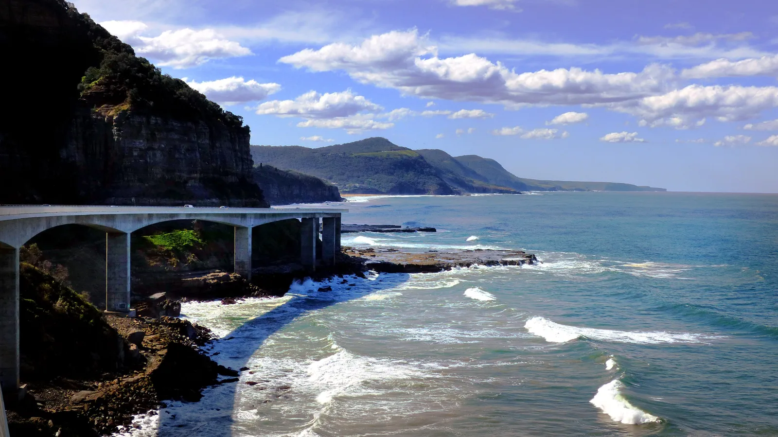
Most people go from Melbourne to Sydney the way a freight truck does: down the Hume, arrive. The ride worth the days goes the long way round, in two versions. One follows the sea. The other crosses the Great Alpine Road, which tops out at 1,840 m and is described as Australia’s highest year-round accessible sealed road.
This motorcycle road trip itinerary covers both, with overnight stops chosen for the rider and what the weather does to each. The short answer: take the coast in three days, or the mountains in four between late spring and autumn.
Which is the best motorcycle route from Melbourne to Sydney?
| Coastal (Princes Highway) | Inland alpine (Great Alpine Road and Alpine Way) | |
|---|---|---|
| Distance | About 1,040 km | About 1,400 km (our route estimate) |
| Days | 3 comfortable, 4 relaxed | 4 |
| Character | Beaches, lakes, headlands, forest and a long run of small coastal towns | Mountain climbs, high passes, empty valleys, cold mornings |
| Best months | September to May | Late November to April |
| Who it suits | Anyone with 3 days, mixed weather or a pillion | Riders who want corners and have a fourth day |
My pick is the coast. It fits three days and suits most weather. The alpine route is for the rider who would rather have a mountain than a beach and can spare a fourth day. It is not for a cold week in July.
The Hume stays on the table as the short version: one very long day or an easy two.
How many days do you need?
Three days for the coast: roughly 320, 235 and 478 km. Two days works only on the Hume; on the coast it is a forced march.
Four days is the relaxed coast: break the last day at Batemans Bay (about 200 km from Eden and about 280 km from Sydney by our route estimates) and ride Kiama and the Sea Cliff Bridge on the last morning, in good light. If you can spare the day, do that.
The alpine route is four days by design. A three day version means 500 km days through mountains.
- Day 1Melbourne to Lakes Entrance320 km
- Day 2Lakes Entrance to Eden235 km
- Day 3Eden to Sydney478 km
Day 1 on the coast: Melbourne to Lakes Entrance
About 320 km, roughly four hours of road time. Lakes Entrance is 40 km south east of Bairnsdale.
The first day is the gentlest: the Princes Highway through Gippsland to a town built around water. The entrance is a managed, artificial channel linking the Gippsland Lakes to Bass Strait, and the waterfront hosts a commercial fishing fleet. Food and beds are the business here, and you can walk to dinner.
Don’t miss: the town’s position between the lakes and Ninety Mile Beach. Walk down to the beach before the light goes.
Day 2 on the coast: Lakes Entrance to Eden
About 235 km, roughly three hours of road time.
This is the quiet day, and it holds the most remote stretch of the trip: Wikivoyage describes Eden to Orbost (185 km) as the remotest on the route, with scattered services. So:
- Fill up in Lakes Entrance, then top up wherever you can before the long run.
- Cann River is the halfway pit stop.
- Keep the stretch for daylight, because of kangaroos.
Mallacoota, about 20 km off the road, is the gateway to Croajingolong National Park if you have a spare half day.
Eden is the most southerly town in New South Wales, on the northern reach of Twofold Bay, with a harbour that George Bass sheltered in during 1798.
Don’t miss: the Eden Killer Whale Museum. Local whaling ran from 1828 to 1930, and the museum tells how a pod of orcas led by one named Old Tom herded humpbacks towards the whalers. His skeleton is displayed there. Check opening hours first.
Day 3 on the coast: Eden to Sydney
About 478 km, roughly seven hours of road time.
This is the long day, with the best set pieces at the end. Start early, so you reach the Illawarra with daylight left.
Stops, in order:
- Pebbly Beach and South Durras for kangaroos. Pebbly Beach is in Murramarang National Park; there is more in our guide to camping at Pebbly Beach.
- Batemans Bay, on the Clyde River, with oysters. This is the logical lunch stop.
- Kiama, where the blowhole can throw about 50 litres of water up to 25 m into the air under the right sea conditions. George Bass wrote about it on 6 December 1797. The smaller Little Blowhole is about 2 km south and is described as more reliable.
- Sea Cliff Bridge, the last set piece before Sydney.
Don’t miss: the Sea Cliff Bridge, which carries Lawrence Hargrave Drive (the Grand Pacific Drive) 455.6 m out over the Tasman Sea between Coalcliff and Clifton. It opened on 11 December 2005, and it exists because a section of the old road was permanently closed in August 2003 after repeated rock falls. The shoulders are about 1.2 m, so it is a place to keep riding, not to stop.
Royal National Park (Wattamolla, Garie Beach) is a better way into Sydney than the motorway if there is daylight left.
The alpine alternative in four days
- Day 1Melbourne to Bright320 km
- Day 2Bright to Corryong over Mount Hotham370 km
- Day 3Corryong to Jindabyne by the Alpine Way245 km
- Day 4Jindabyne to Sydney485 km
Day 1: Melbourne to Bright, about 320 km. Bright sits at the south eastern end of the Ovens Valley, at 319 m, at the foot of tomorrow’s climb.
Day 2: Bright to Corryong over Mount Hotham, about 370 km. This is the big one. The Great Alpine Road reaches 1,840 m over Mount Hotham. From Bright you ride through Harrietville and up to the pass, then down to Omeo, a town founded on gold (found in Livingstone Creek in 1845).
From Omeo the sealed Omeo Highway runs 163 km north to Tallangatta, following the Mitta Mitta River through the Alpine National Park. It is winding, with views that draw motorcycle groups. There is no fuel between Mitta Mitta and Omeo, and no mobile coverage south of Anglers Rest, so ride it with a full tank and tell someone where you are going. Skip the Benambra to Corryong road as a shortcut: one travel account describes it as largely unsealed.
Corryong, about 80 km on from Tallangatta, is the overnight stop. Jack Riley, thought to have inspired “The Man from Snowy River”, is buried in the cemetery.
Day 3: Corryong to Jindabyne via the Alpine Way, about 245 km. The Alpine Way is 121.3 km of sealed road from Jindabyne towards the Victorian border, climbing over Dead Horse Gap at 1,580 m. National Parks NSW describes it as steep, narrow and winding between Khancoban and Thredbo, with limited mobile reception. Rockfalls can happen after rain. Fuel up at Khancoban or Thredbo (check what is open), and give the descent time.
Day 4: Jindabyne to Sydney, about 460 to 510 km. Cooma is 61 km from Jindabyne, Canberra is 180 km, and Sydney is 511 km. Ride Cooma and Canberra, then use the Hume for the quick finish, with coffee at Berrima or Goulburn.
Which direction is better, and where to stop?
On the coast, Sydney to Melbourne has a case: you start with the longest day when you are fresh, see the Sea Cliff Bridge and Kiama early, and finish on the shortest leg. Heading north, the long leg comes last. That is my preference, and the roads work either way. The alpine route works in both directions, because the two hard days are in the middle.
Coast stops: Lakes Entrance, then Eden, with Batemans Bay as a break if you stretch to four days. Both roads are busy from Christmas to the end of January, so sort your beds before you leave.
Alpine stops: Bright, Corryong, then Jindabyne. Omeo is an option for a shorter second day and a longer third.
Weather: what the months actually do
Figures are Open-Meteo historical weather data, 2015 to 2024 averages (open-meteo.com).
| J | F | M | A | M | J | J | A | S | O | N | D | |
|---|---|---|---|---|---|---|---|---|---|---|---|---|
| Coast: best | Best | Best | ||||||||||
| Mountains: best | Best | Best | ||||||||||
| Mountains: snow | Snow | |||||||||||
| Melbourne | 27°25% | 26°20% | 24°23% | 20°29% | 16°36% | 14°35% | 13°42% | 14°40% | 17°41% | 20°39% | 22°36% | 25°28% |
| Canberra | 27°31% | 26°21% | 23°26% | 19°20% | 14°19% | 11°23% | 11°25% | 12°26% | 16°20% | 20°27% | 23°32% | 26°25% |
| Sydney | 27°42% | 26°46% | 25°48% | 22°34% | 20°24% | 17°33% | 17°24% | 18°20% | 21°25% | 22°36% | 24°38% | 26°34% |
| Jindabyne | 24°46% | 23°38% | 20°36% | 17°27% | 12°27% | 9°29% | 9°34% | 10°37% | 13°32% | 17°38% | 20°44% | 23°40% |
- under 10°
- 10 to 15°
- 15 to 20°
- 20 to 25°
- 25 to 30°
- 30° and over
See the figures as a table
| Month | Melbourne | Canberra | Sydney | Jindabyne |
|---|---|---|---|---|
| Jan | 26.5 / 15.2, 25% | 27.4 / 14.9, 31% | 26.6 / 19.4, 42% | 24.2 / 11.9, 46% |
| Feb | 25.6 / 14.5, 20% | 26.1 / 13.9, 21% | 25.9 / 19.0, 46% | 22.9 / 10.9, 38% |
| Mar | 24.1 / 13.7, 23% | 23.4 / 12.2, 26% | 24.8 / 17.9, 48% | 20.3 / 9.5, 36% |
| Apr | 20.1 / 10.8, 29% | 19.2 / 8.5, 20% | 22.4 / 14.5, 34% | 16.5 / 6.0, 27% |
| May | 16.3 / 8.6, 36% | 14.3 / 4.2, 19% | 19.5 / 11.1, 24% | 12.0 / 2.7, 27% |
| Jun | 13.7 / 6.5, 35% | 11.1 / 2.2, 23% | 16.8 / 8.9, 33% | 8.9 / 0.9, 29% |
| Jul | 13.2 / 6.4, 42% | 10.6 / 1.4, 25% | 16.9 / 8.0, 24% | 8.6 / 0.0, 34% |
| Aug | 14.3 / 6.8, 40% | 12.1 / 2.0, 26% | 18.1 / 8.5, 20% | 9.8 / 0.4, 37% |
| Sep | 16.6 / 7.7, 41% | 15.7 / 4.2, 20% | 20.5 / 10.6, 25% | 13.3 / 2.3, 32% |
| Oct | 19.7 / 9.2, 39% | 19.5 / 7.5, 27% | 22.4 / 13.3, 36% | 16.8 / 4.9, 38% |
| Nov | 21.8 / 11.4, 36% | 22.5 / 10.2, 32% | 23.6 / 15.4, 38% | 19.5 / 7.4, 44% |
| Dec | 24.6 / 13.1, 28% | 25.8 / 12.7, 25% | 25.7 / 17.6, 34% | 22.6 / 10.0, 40% |
Jindabyne stands in for the high country; Mount Hotham is higher, so expect colder.
Best months. March and April: Canberra is dry, Sydney’s wet season has eased, and Jindabyne is still mild at midday. For the alpine route, the real window is late November to April. September and October are good on the coast but cold at altitude.
Worst months. June to August for the mountains. Great Alpine Road users must carry chains between Harrietville and Omeo in the declared snow season, and on the Alpine Way, 2WD vehicles must carry chains between Thredbo and Tom Groggin from the June to October long weekends. Check what those rules mean for a motorcycle with the road authority. Treat snow and ice as the end of the alpine option.
Heat, fire and smoke. The NSW Bush Fire Danger Period normally runs 1 October to 31 March. The summer of 2019 to 2020 shows the worst case: the Princes Highway was closed in several places east of Bairnsdale, and on 14 January 2020 Victoria recorded the worst air quality in the world, according to the Australian Institute for Disaster Resilience. That is one summer, not a forecast, but it is why you check fire warnings and closures from December to February.
What it changes on the day. In January, start early and carry water on stretches without services. In April and October, pack a warm layer for the mornings, particularly in Canberra and Jindabyne.
For live conditions, use VicTraffic, Live Traffic NSW and the national park alerts. This post does not tell you whether a road is open today.
Plan it in MotoRidez
Pick curvy routing and MotoRidez plans the coast or mountain version instead of the Hume. Download the route’s offline map before Eden and the Omeo Highway, where coverage drops out. It is free on iPhone and Android; see also our guides to riding in New South Wales, the Victorian High Country and Gippsland and fuel range planning.
Questions riders ask
What is the best motorcycle route from Melbourne to Sydney?
For three days, the coastal Princes Highway: about 1,040 km via Lakes Entrance, Eden, Batemans Bay and Kiama, finishing over the Sea Cliff Bridge. If you have four days and it is between late spring and autumn, the alpine route over Mount Hotham and the Alpine Way is the better ride, but it is longer and more weather dependent.
How long does it take to ride from Melbourne to Sydney by motorbike?
On the Hume Highway the distance is about 870 km, which is one very long day or an easy two. The coastal route is about 1,040 km, and a three day split keeps each day to roughly 235 to 480 km. Add a day if you want to stop for the places the route is about.
Is the Sydney to Melbourne coastal route worth it?
It adds about 170 km over the Hume, but it replaces the freeway with a mostly two lane road past beaches, lakes and headlands. Wikivoyage notes it is freeway grade only near Sydney and Traralgon.
What is the best time of year to ride Melbourne to Sydney?
April is the most forgiving month on our figures: dry days are common, Canberra and the coast are mild, and Jindabyne is still above 16°C at midday. For the alpine route, late November to April avoids the declared snow season. Summer is hotter, busier and carries bushfire risk, so check fire warnings.
Can you ride the Great Alpine Road in winter?
The road usually stays open in winter but is covered in snow and cleared daily, and extreme weather can close the Harrietville to Omeo section. Vehicles are required to carry diamond pattern chains in the declared snow season, so check with the road authority how that applies to a motorcycle. Most riders will do better to take the coast between June and September.
Should I ride Melbourne to Sydney or Sydney to Melbourne?
On the coast, riding south puts the longest day (Eden to Sydney is about 478 km) first, when you are fresh, and finishes on the shortest. Riding north gives you the remote Gippsland stretch early and the Sydney traffic last. Either works; this is a preference, not a rule.
Is the coastal route remote?
Mostly not, but the stretch from Eden to Orbost is about 185 km with scattered services, according to Wikivoyage. Fill up in Eden or Orbost depending on direction, and avoid riding it after dark because of wildlife.
Free, no subscription
Plan the curvy bits. Record the ride.
Watch your
map fill in.
Curvy routing, turn-by-turn voice navigation, ride recording and your ridden-roads map, with nothing behind a paywall.



Join the waitlist
Bring MotoRidez to your roads
The more riders register from your region, the sooner we get there. Put your name down, then send it to your ride group to move your region up the queue.
You're on the list ✓
Nice — you're in the queue
Every rider you bring moves your region up the list. Share it with your mates and your ride groups.