
Ben-Ewa camping, Moreton Island (Gheebulum Kunungai): 4WD, permits and the barge
Ben-Ewa camping on Moreton Island (Gheebulum Kunungai): 12 totem-marked sites, 4WD access, Mulgumpin Camping permits, cold showers, no pets or generators.
No park alerts listed Queensland Parks listed no park alerts for Gheebulum Kunungai (Moreton Island) when checked. Its Moreton Island conditions report was updated on 1 October 2026, and seasonal closures mean not every campsite is open all year. Checked on the operator's alerts page .
 No park alerts listed
Map: Ben-Ewa and what is around it
Pan and zoom. Solid lines are sealed roads, dashed brown lines are gravel and unsealed roads, and purple lines are named twisty roads. Tap a pin or a road for details, and use the buttons to switch layers on and off.
The interactive map needs WebGL, which this browser does not offer. The places around the camp are listed below.
Fuel
- Ampol 20.9 km in a straight line
- BP 23.2 km in a straight line
Food and coffee
- Benny's Cafe 18.7 km
- Coffee House Bakery 18.8 km
- Bread and Books 21.9 km
- Red Rooster 21.9 km
- Village Deli Bongaree 22.0 km
Other camps nearby
- The Wrecks camping area 1.1 km
- Camp site WBS 7 4.0 km
- Comboyoro Point camping area 9.1 km
- Blue Lagoon Sunrover Campsite 10.0 km
- North Point camping area 16.2 km
- Bribie Island Caravan Park 19.0 km
Distances are in a straight line from the camp, not by road. Places and roads come from OpenStreetMap and can be out of date: confirm fuel and opening hours before you rely on them. An unsealed road on the map is not necessarily open to vehicles, and in national parks many are fire trails, so check the park alerts and signs. Map data © OpenStreetMap contributors.
Ben-Ewa camping on Moreton Island puts you in a sheltered, sandy valley on the western side of Gheebulum Kunungai (Moreton Island) National Park, a sand island in Moreton Bay about 58 kilometres north-east of Brisbane. The island has no road connection to the mainland and no sealed roads, so the real planning job is the crossing, the permits and what you carry. This guide covers access, facilities, rules, seasons and the mistakes that trip people up.
What is Ben-Ewa camping area?
Ben-Ewa is a small campground inside Moreton Island National Park, which Queensland renamed Gheebulum Kunungai (Moreton Island) National Park in 2021. Queensland Parks says the name means ‘lightnings’ playground’ in the language of the Quandamooka people. The island is also known as Mulgumpin, and the Quandamooka people were granted native title over it in 2019. Roughly 98 per cent of the island sits within the national park, which was established in 1966.
The operator describes Ben-Ewa as sitting in a valley with shady sites and protection from strong winds. It lies on the western (bay) side of the island, a short distance north of the main barge landing used by Moreton Island Ferries. The listing calls the sheltered bay water popular with young families and school groups.
Queensland Parks lists it as “Ben-Ewa camping area”; Mulgumpin Camping calls it “Ben-Ewa Campground”. Both are the same place.
How do you get to Ben-Ewa?
You cannot drive to Moreton Island. Queensland Parks states that ferries and barges run daily, with extra services in school holidays and on long weekends, and that bookings are essential.
Three routes exist:
- Vehicle barge. According to travel guides, the Micat vehicle ferry leaves from the Port of Brisbane and lands on the beach just north of the Tangalooma Island Resort. It carries large vehicles and also takes walk-on passengers. Sailing days and crossing times vary by season, so read the operator’s current timetable.
- Walk-on passenger ferry. Tangalooma resort boats run from Holt Street Wharf at Pinkenba. They carry passengers only, not vehicles, and land at the resort jetty.
- Private boat. The camping listing warns that private boats face exposed waters at Ben-Ewa and that no public moorings are available.
One travel guide describes Ben-Ewa as the nearest campground to the Tangalooma Wrecks for anyone towing a camper trailer.
Do you need a 4WD to camp at Ben-Ewa?
For the campground, yes. Queensland Parks lists access as high-clearance 4WD or boat. Queensland Parks says four-wheel-drive vehicles are essential for driving on Moreton Island, with high clearance and low-range gearing strongly recommended. A separate listing says all-wheel-drive vehicles without true 4WD, and low-clearance vehicles, are not suitable.
Camper trailers can reach the campground, and parking is beside or near your site. If you have no 4WD, walk on as a passenger and stay in accommodation at Tangalooma or Bulwer, or join a guided tour that includes the sand driving.
The operator describes Ben-Ewa as suited to tents beside the car, walk-in camping, camper trailers and large groups.
Do you need a permit to camp at Ben-Ewa?
Yes, in two parts. Camping and vehicle access permits for the Moreton Island Recreation Area are booked and managed through Mulgumpin Camping, owned and operated by the Quandamooka Yoolooburrabee Aboriginal Corporation. Queensland Parks says its own National Parks booking service does not manage these permits.
- Camping. You need a booking before you arrive, and there is no on-site self-registration. The camping tag, with your booking number, is displayed at your site.
- Vehicle access. A vehicle access permit is required before driving in the recreation area and must be displayed on the windscreen.
Fees apply for both and change from year to year, so check the Mulgumpin Camping fees page rather than a figure you saw elsewhere. If you are booking for the first time since July 2024, Queensland notes a new customer account is created automatically with your next booking.
4WD onlyAccess
RequiredBooking
Up to 12Sites
ColdShowers
What facilities does Ben-Ewa camping area have?
The operator lists the following:
- Up to 12 medium-sized, well-defined sand sites, each marked with a totem.
- Hybrid toilets.
- Cold showers.
- A waste transfer station for portable toilets.
- Water that must be treated before drinking.
- A Queensland Parks Wi-Fi hotspot, according to the Parks listing.
- Some shade from the valley setting.
Seasonal closures mean not every site is open all year. The pages I could reach do not state which months, so confirm what is open for your dates when you book.
There is no shop at the campground. Mobile coverage is described as poor or unreliable, though it may improve near Tangalooma Resort. Plan to have no signal when you need it.
Does Ben-Ewa have showers and toilets?
Yes. The camping area has cold showers and non-flush hybrid toilets, and portable toilet owners can empty cassettes at the waste transfer station. Water must be treated before drinking.
Are fires and generators allowed?
Campfires are allowed only in the existing fire sites, and fire bans or prohibitions still apply. Queensland Parks’ packing list includes untreated mill off-cut firewood and an axe, and it recommends fuel or gas stoves over open fires. Generators are not permitted.
Is Ben-Ewa dog friendly?
No. Queensland Parks states that domestic animals are not allowed in the national park and recreation area, and the Ben-Ewa listing says no pets. A dog arriving by boat must stay on the boat. If you travel with a dog, camp on the mainland instead.
Can you camp at Ben-Ewa without booking?
No. Both the campsite and the vehicle permit need to be arranged before you cross. A travel guide advises booking the vehicle barge at least four weeks ahead for weekends and notes that school holidays can sell out many months in advance. Book the crossing and the campsite together, since one without the other leaves you stranded.
When is the best time to camp at Ben-Ewa?
Brisbane Airport is the nearest Bureau of Meteorology station with long-term figures and sits on the same bay. Moreton Island will vary a little, but the pattern holds.
| Season | Months | Typical conditions |
|---|---|---|
| Summer | Dec to Feb | Hot and humid, daily maximum 28 to 29 degrees, wettest period with thunderstorms |
| Autumn | Mar to May | Warm days easing to mild, rainfall dropping |
| Winter | Jun to Aug | Days around 21 to 22 degrees, nights 9 to 11 degrees, among the driest months |
| Spring | Sep to Nov | Warming up, daily maximum 24 to 27 degrees |
July to September are the driest months in the Brisbane record. Humpback whales pass the island between about June and November according to one guide, which is another reason to go in the cooler half of the year. Summer is the busiest season according to one guide, with thunderstorms common from November to March, and Brisbane lies in a tropical cyclone risk area. Check the Bureau of Meteorology forecast and Queensland Parks alerts before you leave.
What is there to do near Ben-Ewa?
The campground’s listed activities are swimming, fishing, boating, canoeing and kayaking, and walking. Beyond the camp:
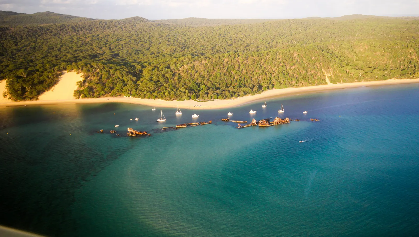
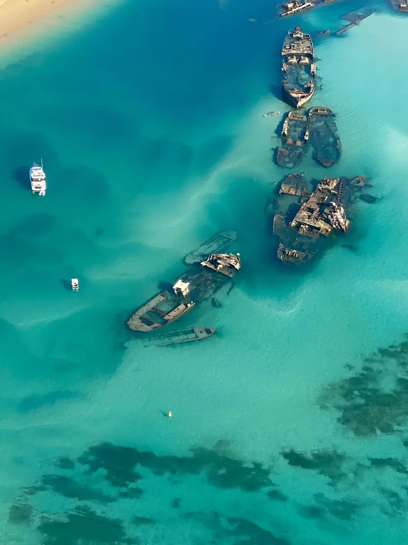
- Tangalooma Wrecks. About 15 vessels were deliberately sunk off the beach to form an anchorage, a short distance from the resort. Snorkelling and kayak tours run there. A travel guide warns against swimming out from the beach because of strong currents and suggests a guided boat tour instead.
- The Desert and Mount Tempest. The big sand blow sits inland. Sources disagree on walking distances, so check current track notes. Mount Tempest, the island’s high point at roughly 280 metres, is a steep walk.
- Blue Lagoon and Honeyeater Lake. These freshwater lakes lie among the dunes.
- Cape Moreton. The only rock outcrop on the island, at the north-eastern tip.
Wikipedia lists sand tobogganing and whale watching among the island’s draws, and dolphins, dugongs and wobbegongs are reported around the wrecks.
Is it safe? Rules, wildlife and tides
- Food and rubbish. Feral pigs roam the island, so store food and rubbish in strong, lockable containers. The Ben-Ewa listing says to take all rubbish home.
- Tracks. Keep to defined vehicle tracks and walking trails, and camp only in designated areas to protect fragile vegetation.
- Tides. Beach driving is tide-dependent. Guides give different windows, so read the current Queensland Parks guidance before you leave the barge landing.
- Medical. The island is remote with limited facilities and no resident doctor. Carry a first-aid kit.
- Fire. A bushfire in October 2025 burned about 2,300 hectares, so obey fire bans.
What supplies and services are nearby?
Supplies are thin. One guide reports two small stores on the island, at Bulwer and Kooringal, and says fuel is sold only at Bulwer in 20-litre drums. Queensland Parks says to carry enough fuel from the mainland. Stock up on food, ice, water and gas in Brisbane before the crossing.
What should you bring to Ben-Ewa?
- Drinking water and sterilising tablets.
- Rubbish bags and lockable containers for food.
- Firewood, if you plan a fire and there is no ban.
- Sunscreen, insect repellent and a first-aid kit.
- Tyre gauge, compressor, recovery tracks and a shovel.
- Your camping tag and vehicle permit.
- Offline maps, because coverage is poor.
A one-night plan
Take the morning barge, drive off the beach near Tangalooma and continue the short distance north to Ben-Ewa. Set up, then spend the afternoon on the bay shore. Keep food sealed against pigs, and pack early the next day so you reach your return sailing with time to spare.
A weekend plan
Arrive Friday. Spend Saturday on a guided Tangalooma Wrecks snorkel or kayak tour, then drive inland to the Desert or Mount Tempest, allowing for tide windows. Sunday, pack up and return on the afternoon barge.
Who is Ben-Ewa for, and who should choose elsewhere?
It suits car campers with a high-clearance 4WD, camper trailer owners, families who want sheltered water and groups who want defined sites. It is a poor fit for dogs, for city cars and for anyone expecting a shop.
Alternatives on the same island include the Blue Lagoon and Comboyuro Point camping areas, plus the camping zones, all listed by Queensland Parks. Choose a mainland caravan park if you travel with a pet, or accommodation at Tangalooma or Bulwer if you want no vehicle.
Planning checklist
- Choose dates and book the barge crossing.
- Book the camping tag through Mulgumpin Camping.
- Buy the vehicle access permit and display it on the windscreen.
- Check Queensland Parks alerts and fire ban status.
- Check tide times for the beach drive.
- Pack water, fuel, food, recovery gear and rubbish bags.
- Download offline maps.
Common mistakes
- Booking the campsite but not the barge.
- Turning up in an all-wheel-drive crossover.
- Bringing a dog.
- Assuming the water is drinkable untreated or the showers are warm.
- Leaving food out where pigs can reach it.
- Relying on fuel or supplies on the island.
- Driving the beach at the wrong point of the tide.
More from the operator: parks.des.qld.gov.au/parks/moreton-island/camping/ben-ewa-camping-area (search summary; 403).
Plan it in the app
Save the camp on your route in MotoRidez and the planner shows road closures along the way, and where your tank runs out once you have entered the range of your vehicle. Save the route for offline use before you lose signal: it saves the corridor around your route, not a whole region.
Details come from the operator’s own records and pages, read on 20 October 2026, and change. We do not show prices or availability. Confirm fees, bookings, closures and fire rules with the operator before you go.
Questions riders ask
Can you camp at Ben-Ewa on Moreton Island?
Yes. Ben-Ewa is an official camping area in Gheebulum Kunungai (Moreton Island) National Park with up to 12 totem-marked sites, and a booking is required.
How do you book Ben-Ewa camping?
Camping and vehicle access permits for the Moreton Island Recreation Area are booked through Mulgumpin Camping, not the main Queensland National Parks booking service. The barge crossing is booked separately.
Do you need a 4WD to camp at Ben-Ewa?
Queensland Parks lists access as high-clearance 4WD or boat. Camper trailers can reach the campground, and the island has no sealed roads.
Does Ben-Ewa have showers and toilets?
Yes. There are cold showers and non-flush hybrid toilets, a waste transfer station for portable toilets, and water that must be treated before drinking. There is also a QldParks-Wifi hotspot, but mobile coverage is poor and unreliable.
Can you have a campfire at Ben-Ewa?
Only in existing fire sites, and never during a fire ban or prohibition. Queensland Parks recommends fuel or gas stoves and says generators are not permitted.
Is Ben-Ewa dog friendly?
No. Domestic animals are not allowed in the national park and recreation area. A dog arriving by boat must stay on the boat.
What is Gheebulum Kunungai?
It is the 2021 name for Moreton Island National Park. Queensland Parks says it means 'lightnings' playground' in the language of the Quandamooka people, who jointly manage the park with Queensland Parks and Wildlife Service.
Free, no subscription
Plan the curvy bits. Record the ride.
Watch your
map fill in.
Curvy routing, turn-by-turn voice navigation, ride recording and your ridden-roads map, with nothing behind a paywall.



Join the waitlist
Bring MotoRidez to your roads
The more riders register from your region, the sooner we get there. Put your name down, then send it to your ride group to move your region up the queue.
You're on the list ✓
Nice — you're in the queue
Every rider you bring moves your region up the list. Share it with your mates and your ride groups.