
Tasmania in 7 days by motorcycle: where 21% of the island is World Heritage
A Tasmania 7 day itinerary by motorcycle: daily distances, where to sleep, which way round, plus 5 and 10 day versions and month-by-month weather.
Tasmania is the one place where you can plan a motorcycle road trip and a week-long itinerary without once needing to be somewhere. About 21% of the island is World Heritage, and Queenstown, the town at the heart of the west coast, averages 2,408 mm of rain a year. The distances are short and the quiet is real, so the days end up decided by the weather more than the map.
This is the plan for it. The Tasmania Ring post argues that the loop is worth riding. This one tells you which way round, where to sleep, what to stop for and how far each day is.
The short answer: arrive at Devonport, ride the east coast first, spend two nights in Hobart, cross the highlands to Queenstown, and finish through Strahan and Cradle Mountain back at Devonport. Seven nights, seven riding days, and a short last day so the ferry is never a rush.
How many days do you need for Tasmania?
Seven. The ring is about 1,180 km, which is around 14 hours of riding. Seven days spreads that across short days with room for two or three proper stops. Five days and ten days are laid out near the end of this post.
Which way round, and why
From Devonport, go east first and finish on the west coast. Three reasons.
The east is drier. Climate records give Launceston about 666 mm a year, against 2,408 mm at Queenstown.
The west is where snow and ice can close or slow the highland roads, and the part of the trip most likely to need a changed plan. By the time you reach it you have forecasts behind you and, because the first four days are short, you can trade a day.
And it puts the shortest day last. On day seven you ride about 135 km to Devonport, so a slow wet morning on the Murchison Highway does not threaten the ferry.
If you fly into Hobart or Launceston, keep the principle and not the direction. From Hobart: peninsula, east coast to Launceston, Devonport and Cradle, then down the west coast and home on the Lyell Highway. From Launceston the loop is the same one, joined about 93.5 km east of Devonport on the Bass Highway.
- Day 1Devonport to St Helens255 km
- Day 2St Helens to Bicheno and Freycinet85 km
- Day 3Bicheno to Hobart165 km
- Day 4Hobart and the Tasman Peninsula, return190 km
- Day 5Hobart to Queenstown248 km
- Day 6Queenstown, Strahan and Cradle Valley150 km
- Day 7Cradle Valley to Devonport135 km
Day 1: Devonport to St Helens, about 255 km
The Spirit of Tasmania crossing between Geelong and Devonport takes about 9 to 11 hours and is typically overnight. Check the timetable and motorcycle boarding rules with the operator.
The Bass Highway to Launceston is about 93.5 km. From there the Tasman Highway runs to Scottsdale (about 62 km) and on to St Helens (about 160 km). Plan for roughly three hours of riding before stops.
The stop: Scottsdale, for fuel and a break. Overnight: St Helens, the base for the Bay of Fires. Don’t miss: the Bay of Fires was named by Captain Tobias Furneaux in 1773 after he saw Aboriginal fires on the beaches. Its granite looks orange because of lichen, and it runs from Binalong Bay to Eddystone Point.
Day 2: St Helens to Bicheno and Freycinet, about 85 km (plus the spur)
A deliberately short day. St Helens to Bicheno is about 84 km on the Tasman Highway, and Coles Bay is another 37 km from Bicheno each way. Spend the morning at the Bay of Fires, the afternoon at Freycinet.
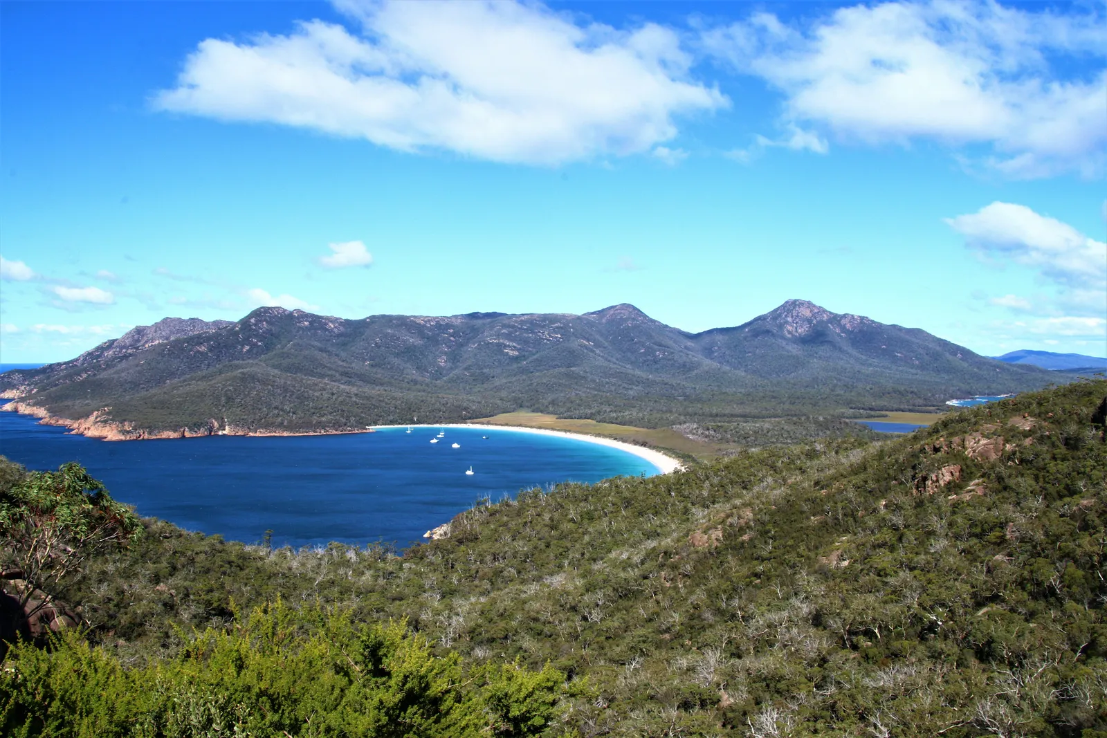
The stop: Freycinet National Park, Tasmania’s oldest national park (founded 1916, alongside Mount Field). It covers 169 km² and Wineglass Bay is inside it. Overnight: Bicheno (about 950 people) or Coles Bay. Don’t miss: Bicheno’s little penguin colony on Diamond Island, with guided tours to a protected rookery. Book tours directly and check seasons.
Day 3: Bicheno to Hobart, about 165 km
Down the Tasman Highway through Swansea (43 km from Bicheno) and Orford, then Sorell and into Hobart. The highway is 410 km end to end, and this is its best-behaved stretch.
About two and a half hours of riding, so get off the bike early and see Hobart on foot.
The stop: Swansea, for a break overlooking Great Oyster Bay. Overnight: Hobart, two nights. Don’t miss: an unhurried evening. Tomorrow is the exposed day.
Day 4: Hobart and the Tasman Peninsula, about 190 km round trip
The peninsula is about 75 km south-east of Hobart on the Arthur Highway, and Port Arthur is about 97 km. It is a there-and-back with a base in the city, so you ride with no luggage.
The stop: Eaglehawk Neck, an isthmus less than 30 m wide at its narrowest, where guards and dogs once stopped convicts escaping. Tasmans Arch and Devils Kitchen are a 20-minute, 600 m sealed circuit nearby. Fuel and food: Port Arthur. Overnight: Hobart again. Don’t miss: the dolerite sea cliffs, which Parks Tasmania describes as Australia’s highest, ending in three capes: Pillar, Hauy and Raoul. Cape Hauy is a 4-hour, 9.4 km return walk from Fortescue Bay if you want it.
Port Arthur was a penal settlement from 1830 to 1877 and is part of the Australian Convict Sites World Heritage listing.
Swap this day for a Hobart rest day if the forecast is bad, and check the Bureau of Meteorology’s warnings before committing.
Day 5: Hobart to Queenstown, about 248 km
The big day. The Lyell Highway runs from Granton through New Norfolk, Hamilton, Ouse, Wayatinah and Tarraleah to Derwent Bridge, which sits between Lake St Clair to the north and Lake King William to the south. Then the West Coast Range, and Queenstown.
Around three hours of riding. Fill up in Hobart or New Norfolk, and top up at Ouse or Derwent Bridge.
The stop: Derwent Bridge. If you start early, Mount Field National Park is 64 km north-west of Hobart, with the 20-minute return walk to Russell Falls on boardwalks. Overnight: Queenstown (1,808 people at the 2021 census). Don’t miss: the final descent. The Lyell Highway drops from Gormanston Hill into Queenstown in a run of hairpins known locally as the 99 Bends, although one travel guide counts 44. A side road at the top leads to Iron Blow lookout over a former open-cut mine.
Queenstown’s bare hills come from tree clearing for smelters, about 40 years of smelter fumes and heavy rain stripping the topsoil.
Day 6: Queenstown to Strahan to Cradle Valley, about 150 km plus the valley road
Queenstown to Strahan is about 41 km. Strahan sits on Macquarie Harbour and is the base for boat trips to the lower Gordon River and to Sarah Island, once a penal settlement the article calls the harshest in the Australian colonies. The long-running play The Ship That Never Was is staged in town.
From Strahan it is about 43 km to Zeehan, then the Murchison Highway north. The turn to Cradle Mountain, Belvoir Road, is about 80 km from the highway’s northern end.
The stop: Strahan harbour. Overnight: Cradle Valley. Don’t miss: Cradle Mountain stands at 1,545 m above Dove Lake, and the road ends at the lake. Cradle Valley is the place to take the weather seriously, as the weather section below explains.
Day 7: Cradle Valley to Devonport, about 135 km plus the side road
North on the Murchison Highway for about 80 km to Somerset, then east on the Bass Highway for about 54 km to Devonport. A few hours of riding, with time to spare for the ferry.
The stop: Somerset, the fuel and food break. Overnight: Devonport, or on the ferry. Check the boarding and check-in times on the Spirit of Tasmania site.
What does the weather do in Tasmania?
Monthly climate for Hobart, Launceston and Queenstown. Source: Open-Meteo historical weather data (ERA5 reanalysis), 2015 to 2024 averages.
| J | F | M | A | M | J | J | A | S | O | N | D | |
|---|---|---|---|---|---|---|---|---|---|---|---|---|
| Best months | Best months | Best months | ||||||||||
| Cold and wet | Cold and wet | |||||||||||
| Hobart | 23°28% | 22°28% | 20°26% | 18°25% | 14°30% | 12°27% | 12°31% | 13°36% | 15°32% | 17°35% | 19°40% | 21°33% |
| Launceston | 25°25% | 24°28% | 22°24% | 18°22% | 15°31% | 12°31% | 12°36% | 13°39% | 15°33% | 17°33% | 20°32% | 23°24% |
| Queenstown | 21°46% | 20°49% | 18°52% | 15°61% | 13°64% | 11°59% | 11°67% | 11°71% | 13°73% | 15°59% | 17°61% | 19°56% |
- under 10°
- 10 to 15°
- 15 to 20°
- 20 to 25°
- 25 to 30°
- 30° and over
See the figures as a table
| Month | Hobart | Launceston | Queenstown |
|---|---|---|---|
| Jan | 22.6 / 13.0, 28% | 24.7 / 13.2, 25% | 20.7 / 11.4, 46% |
| Feb | 21.8 / 12.3, 28% | 23.5 / 12.5, 28% | 19.7 / 11.0, 49% |
| Mar | 20.3 / 11.2, 26% | 21.7 / 11.2, 24% | 18.4 / 10.4, 52% |
| Apr | 17.5 / 9.0, 25% | 18.1 / 8.5, 22% | 15.3 / 8.9, 61% |
| May | 14.4 / 6.7, 30% | 14.6 / 6.3, 31% | 12.8 / 7.1, 64% |
| Jun | 12.3 / 5.2, 27% | 12.3 / 4.5, 31% | 11.1 / 5.9, 59% |
| Jul | 11.9 / 4.6, 31% | 11.8 / 4.1, 36% | 10.6 / 5.3, 67% |
| Aug | 12.8 / 4.8, 36% | 12.8 / 4.3, 39% | 11.1 / 5.1, 71% |
| Sep | 14.8 / 6.0, 32% | 14.9 / 5.6, 33% | 12.6 / 5.8, 73% |
| Oct | 16.8 / 7.6, 35% | 17.3 / 7.0, 33% | 15.2 / 6.7, 59% |
| Nov | 18.8 / 9.6, 40% | 19.9 / 9.3, 32% | 17.1 / 8.4, 61% |
| Dec | 20.9 / 11.1, 33% | 22.5 / 11.1, 24% | 18.7 / 9.8, 56% |
Best months: December to March, with the lowest west-coast rain share too. Wikipedia notes that January and February west-coast rainfall is only about a third of July and August’s.
Shoulder months: October, November and April. Queenstown still sees rain on most days, so pack thermal layers and start after the frost has gone.
Worst months: June to August, cold everywhere. September is the wettest month in Queenstown in this data. Snow is common in elevated areas until October.
Snow and ice on the west highlands. The Cradle Mountain weather station at 903 m averages 47.9 snowy days a year, and snow can fall in any month. The Murchison Highway is described as susceptible to ice and snow in winter. Check TasALERT and Tasmania Police community alerts before you leave, and do not take a road that has been flagged.
Bushfire season. The Tasmania Fire Service describes a summer danger period from November to March. Smoke can reduce visibility, and road closures can come with little warning, so check TasALERT.
Wind on the Tasman Peninsula. Wikipedia describes spring as Tasmania’s windiest season, the capes are exposed, and a crosswind on a loaded bike is tiring. Keep day four flexible.
Where to sleep each night
- Night 1: St Helens. Closest base for the Bay of Fires, about 160 km from Launceston.
- Night 2: Bicheno or Coles Bay. One or other, depending on whether you want the penguins or the national park gate.
- Nights 3 and 4: Hobart. Two nights means one unpack and one day with an empty bike.
- Night 5: Queenstown. Small, practical, and a good place to park after a long day.
- Night 6: Cradle Valley. Or Strahan, if you swap days and sleep on the harbour.
- Night 7: Devonport. Close to the ferry and set up for a calm morning.
Tasmania in 5 days and in 10
Five days: Day 1 Devonport to St Helens (about 255 km), day 2 St Helens to Hobart (about 249 km), day 3 Hobart to Queenstown (about 248 km), day 4 Queenstown to Strahan and Cradle Valley (about 150 km), day 5 Cradle to Devonport (about 135 km). You miss Freycinet and the peninsula, and the ring becomes a transit with highlights.
Ten days: add a second night at Freycinet or Bicheno, a second night on the Tasman Peninsula, a night in Strahan and a rest day at Cradle Valley, and you can pick up the best roads in Tasmania without hurrying. For the quieter north-west, see the roads of northern and western Tasmania.
Fuel and range
The west coast empties out quickly. Fill up in Hobart, Queenstown, and Zeehan or Strahan before you go north, and do not rely on a pump after dark. The fuel range guide has a quick method for working out your weakest tank.
Plan it in MotoRidez
Plan the loop as a curvy route, then save offline maps for the corridor so the west coast does not depend on signal. The app gives you turn-by-turn voice navigation and records each ride. How to plan a curvy route walks through it.
Questions riders ask
Is 7 days enough for Tasmania by motorcycle?
Yes, for the ring. The loop from Devonport is about 1,180 km, and seven days keeps the longest day around 250 km, which leaves time for Freycinet, the Tasman Peninsula and the west coast. Fewer than five days turns it into a transit; more than ten and you will be repeating roads.
Which way should I ride around Tasmania?
From Devonport, ride the east coast first and finish on the west. The east is drier, so you start on easy roads, and you reach the highland and west coast section late, when you can read the forecast and swap days. If you fly into Hobart, run the same idea the other way: peninsula, east coast, Launceston, then the west coast home.
How far is Hobart to Queenstown?
About 248 km by road, on the Lyell Highway through New Norfolk, Ouse, Derwent Bridge and over Gormanston Hill. Allow a long morning and an afternoon of stops rather than a straight run, and fill up before you leave Hobart.
When is the best time of year to ride in Tasmania?
December to March is the warmest window, with Launceston averaging daily highs of about 22 to 25°C. October, November and April are workable if you pack for cold mornings. June to August brings highs of about 11 to 13°C and snow on higher roads.
Does it snow in Tasmania in summer?
Not on the coast, but the highlands can see snow in any month. Cradle Mountain has snow on average on about 48 days a year at the 903 m weather station, and local operators say it can fall any time from May to November. Carry cold and wet layers even in February.
How long is the ferry from Melbourne to Devonport?
The Spirit of Tasmania crossing between Geelong and Devonport takes about 9 to 11 hours and is typically overnight. Check the current timetable and your motorcycle booking details with the operator before you plan your first riding day around the arrival.
Can I do Tasmania in 5 days?
Yes, by dropping the Tasman Peninsula and the Freycinet night. Devonport to St Helens, St Helens to Hobart, Hobart to Queenstown, Queenstown to Cradle Valley and Cradle to Devonport covers the ring in five riding days with the longest day about 250 km.
Free, no subscription
Plan the curvy bits. Record the ride.
Watch your
map fill in.
Curvy routing, turn-by-turn voice navigation, ride recording and your ridden-roads map, with nothing behind a paywall.



Join the waitlist
Bring MotoRidez to your roads
The more riders register from your region, the sooner we get there. Put your name down, then send it to your ride group to move your region up the queue.
You're on the list ✓
Nice — you're in the queue
Every rider you bring moves your region up the list. Share it with your mates and your ride groups.